|
|
Antenna Structure Registration 1022840 |
 |
Registration Info | Registration Number: 1022840 |
| File Number: A1341894 |
| FAA Study: 2017-AGL-3739-OE |
| FAA Issue Date: 03/03/2017 |
| Status: Constructed |
| Date Constructed: 06/05/1992 |
| NEPA: N |
Structure Info
| Structure Type: GTOWER |
| Structure Coordinates: 41-3-26.0 N 80-38-21.0 W (NAD 83) |
| Structure Coordinates: 41-03-25.8 N 80-38-21.7 W (Converted to NAD 27) |
| Structure Address: 4040 Simon Road |
| Structure City: Youngstown, OH |
| Structure County: Mahoning County |
| Painting & Lighting Info |
FAA Circular #: 70/7460-1L |
FAA Chapters: 3, 4, 5, 12 |
Remarks: PRIOR STUDY 1997-AGL-1963-OE |
| Elevation Info |
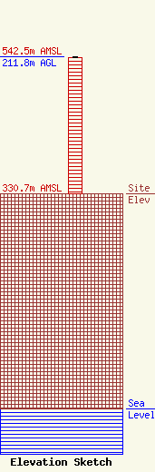
Site Elevation: 330.7 meters (1085 ft) |
| Height of Structure: 210.3 meters (690 feet) |
| Overall Height Above Ground: 211.8 meters (695 feet) |
| Overall Height Above Mean Sea Level: 542.5 meters (1780 feet) |
| Owner Info | VB Nimbus, LLC
22 W Atlantic Avenue
Delray Beach, FL 33444
(561) 406-4015
fcc-faa@verticalbridge.com |
| Contact Info | VB Nimbus, LLC
22 W Atlantic Avenue
Delray Beach, FL 33444
Richard Hickey
(561) 406-4015
fcc-faa@verticalbridge.com |
