|
|
Antenna Structure Registration 1022880 |
 |
Registration Info | Registration Number: 1022880 |
| File Number: A1176135 |
| FAA Study: 2020-ANE-5616-OE |
| FAA Issue Date: 10/07/2020 |
| Status: Constructed |
| Date Constructed: 08/19/2011 |
| NEPA: N |
Structure Info
| Structure Type: GTOWER |
| Structure Coordinates: 46-45-51.9 N 67-59-20.5 W (NAD 83) |
| Structure Coordinates: 46-45-51.7 N 67-59-22.4 W (Converted to NAD 27) |
| Structure Address: 427 Caribou Highway (us Rt 1) |
| Structure City: Presque Isle, ME |
| Structure County: Aroostook County |
| Painting & Lighting Info |
FAA Circular #: 70/7460-1L |
FAA Chapters: 3, 4, 5, 12 |
Remarks: PRIOR STUDY 2002-ANE-338-OE |
| Elevation Info |
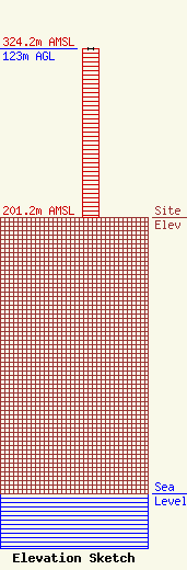
Site Elevation: 201.2 meters (660 ft) |
| Height of Structure: 123 meters (404 feet) |
| Overall Height Above Ground: 123 meters (404 feet) |
| Overall Height Above Mean Sea Level: 324.2 meters (1064 feet) |
| Owner Info | Townsquare Media of Presque Isle, Inc.
1 Manhattanville Road
Purchase, NY 10577
(203) 861-0900
fcccontact@townsquaremedia.com |
| Contact Info | Townsquare Media of Presque Isle, Inc.
1 Manhattanville Road
Purchase, NY 10577
(203) 861-0900
fcccontact@townsquaremedia.com |
