|
|
Antenna Structure Registration 1023850 |
 |
Registration Info | Registration Number: 1023850 |
| File Number: A1344993 |
| FAA Study: 87-AGL-1543-OE |
| FAA Issue Date: 12/04/1987 |
| Status: Constructed |
| Date Constructed: 01/01/1979 |
| FAA EMI: N |
| NEPA: N |
Structure Info
| Structure Type: TOWER |
| Structure Coordinates: 45-33-36.0 N 94-8-21.0 W (NAD 83) |
| Structure Coordinates: 45-33-36.1 N 94-08-20.0 W (Converted to NAD 27) |
| Structure Address: 640 Lincoln Ave Se |
| Structure City: Saint Cloud, MN |
| Structure County: Benton County |
| Painting & Lighting Info |
FCC Paragraph(s): 1, 3, 4, 13, 21 |
Remarks: RED LIGHTS/PAINT |
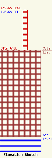
| Elevation Info |
Site Elevation: 313 meters (1027 ft) |
| Height of Structure: 145.7 meters (478 feet) |
| Overall Height Above Ground: 146.6 meters (481 feet) |
| Overall Height Above Mean Sea Level: 459.6 meters (1508 feet) |
| Owner Info | Vertical Bridge NTCF, LLC
22 W Atlantic Avenue
Delray Beach, FL 33444
(561) 406-4015
fcc-faa@verticalbridge.com |
| Contact Info | Vertical Bridge NTCF, LLC
22 W Atlantic Avenue
Delray Beach, FL 33444
Richard Hickey
(561) 406-4015
fcc-faa@verticalbridge.com |
