|
|
Antenna Structure Registration 1023862 |
 |
Registration Info | Registration Number: 1023862 |
| File Number: A1308101 |
| FAA Study: 73-GL-1663-OE |
| FAA Issue Date: 02/28/1974 |
| Status: Constructed |
| Date Constructed: 01/01/1962 |
| NEPA: N |
Structure Info
| Structure Type: TOWER |
| Structure Coordinates: 46-55-42.0 N 95-0-23.0 W (NAD 83) |
| Structure Coordinates: 46-55-42.1 N 95-00-21.9 W (Converted to NAD 27) |
| Structure Address: Hwy 34e 3.2 Km E |
| Structure City: Park Rapids, MN |
| Structure County: Hubbard County |
| Painting & Lighting Info |
FCC Paragraph(s): 1, 3, 4, 13, 21 |
Remarks: RED LIGHTS/PAINT |
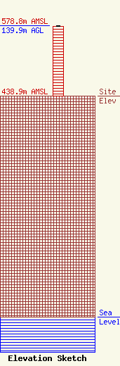
| Elevation Info |
Site Elevation: 438.9 meters (1440 ft) |
| Height of Structure: 139 meters (456 feet) |
| Overall Height Above Ground: 139.9 meters (459 feet) |
| Overall Height Above Mean Sea Level: 578.8 meters (1899 feet) |
| Owner Info | De La Hunt Media, Inc.
838
Park Rapids, MN 56470
(703) 887-6000
Butch@DeLaHuntMedia.com |
| Contact Info | De La Hunt Media, Inc.
838
Park Rapids, MN 56470
Edward De La Hunt
(703) 887-6000
Butch@DeLaHuntMedia.com |
