|
|
Antenna Structure Registration 1023949 |
 |
Registration Info | Registration Number: 1023949 |
| File Number: A1329827 |
| FAA Study: 94-ASW-1233-OE |
| Status: Constructed |
| Date Constructed: 12/21/1974 |
| FAA EMI: N |
| NEPA: N |
Structure Info
| Structure Type: TOWER |
| Structure Coordinates: 30-20-26.0 N 89-57-53.0 W (NAD 83) |
| Structure Coordinates: 30-20-25.3 N 89-57-52.7 W (Converted to NAD 27) |
| Structure Address: 4.0 Km Nw |
| Structure City: Lacombe, LA |
| Structure County: St. Tammany Parish |
| Painting & Lighting Info |
FAA Circular #: 70/7460-1H |
FAA Chapters: 4, 8, 13 |
| Elevation Info |
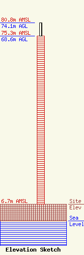
Site Elevation: 6.7 meters (22 ft) |
| Height of Structure: 68.6 meters (225 feet) |
| Overall Height Above Ground: 74.1 meters (243 feet) |
| Overall Height Above Mean Sea Level: 80.8 meters (265 feet) |
| Owner Info | Christwood
100 Christwood Blvd..
Covington, LA 70433-4606
(985) 292-1211
sholzhalb@christwoodrc.com |
| Contact Info | Hardy, Carey, Chautin & Balkin, LLP
1080 West Causeway Approach
Mandeville, LA 70471
Mark Balkin
(985) 629-0750
mbalkin@hardycarey.com |
