|
|
Antenna Structure Registration 1024085 |
 |
Registration Info | Registration Number: 1024085 |
| File Number: A1155325 |
| FAA Study: 2016-ASO-27228-OE |
| FAA Issue Date: 10/20/2016 |
| Status: Constructed |
| Date Constructed: 05/01/1993 |
| NEPA: N |
Structure Info
| Structure Type: GTOWER |
| Structure Coordinates: 35-35-47.3 N 78-45-16.7 W (NAD 83) |
| Structure Coordinates: 35-35-46.7 N 78-45-17.7 W (Converted to NAD 27) |
| Structure Address: Hwy 42, Near Hwy 401 (311112 / Fuquay Varina - Wake Nc) |
| Structure City: Fuquay-varina, NC |
| Structure County: Wake County |
| Painting & Lighting Info |
FAA Circular #: 70/7460-1L |
FAA Chapters: 4, 8, 12 |
Remarks: PRIOR STUDY 2016-ASO-6150-OE |
| Elevation Info |
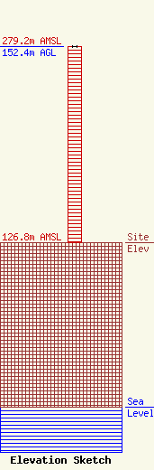
Site Elevation: 126.8 meters (416 ft) |
| Height of Structure: 152 meters (499 feet) |
| Overall Height Above Ground: 152.4 meters (500 feet) |
| Overall Height Above Mean Sea Level: 279.2 meters (916 feet) |
| Owner Info | American Towers, LLC
10 Presidential Way
Woburn, MA 01801
(781) 926-4500
faa-fcc@americantower.com |
| Contact Info | American Towers, LLC
10 Presidential Way
Woburn, MA 01801
(781) 926-4500
faa-fcc@americantower.com |
