|
|
Antenna Structure Registration 1024121 |
 |
Registration Info | Registration Number: 1024121 |
| File Number: A1099936 |
| FAA Study: 93-AGL-1933-OE |
| FAA Issue Date: 07/09/1993 |
| Status: Constructed |
| Date Constructed: 01/01/1993 |
| FAA EMI: N |
| NEPA: N |
Structure Info
| Structure Type: TOWER |
| Structure Coordinates: 44-10-20.0 N 94-2-24.0 W (NAD 83) |
| Structure Coordinates: 44-10-20.1 N 94-02-23.2 W (Converted to NAD 27) |
| Structure Address: 1807 Lee Blvd |
| Structure City: North Mankato, MN |
| Structure County: Nicollet County |
| Painting & Lighting Info |
FCC Paragraph(s): 1, 3, 4, 13, 21 |
Remarks: RED LIGHTS/PAINT |
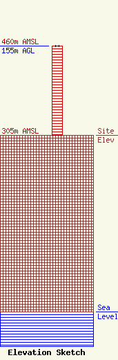
| Elevation Info |
Site Elevation: 305 meters (1001 ft) |
| Height of Structure: 155 meters (509 feet) |
| Overall Height Above Ground: 155 meters (509 feet) |
| Overall Height Above Mean Sea Level: 460 meters (1509 feet) |
| Owner Info | Vertical Bridge S3 Assets, LLC
750 Park of Commerce Dr.
Boca Ratonq, FL 33487
(561) 406-4015
FCC-FAA@verticalbridge.com |
| Contact Info | Vertical Bridge S3 Assets, LLC
750 Park of Commerce Dr.
Boca Ratonq, FL 33487
Richard Hickey
(561) 406-4015
FCC-FAA@verticalbridge.com |
