|
|
Antenna Structure Registration 1024128 |
 |
Registration Info | Registration Number: 1024128 |
| File Number: A1140934 |
| FAA Study: 2019-AGL-9367-OE |
| FAA Issue Date: 06/03/2019 |
| Status: Constructed |
| Date Constructed: 01/01/1994 |
Structure Info
| Structure Type: GTOWER |
| Structure Coordinates: 46-47-20.0 N 92-7-5.3 W (NAD 83) |
| Structure Coordinates: 46-47-20.2 N 92-07-04.6 W (Converted to NAD 27) |
| Structure Address: 1120 E. Orange St. (mn22229-a) |
| Structure City: Duluth, MN |
| Structure County: St. Louis County |
| Painting & Lighting Info |
FAA Circular #: 70/7460-1L |
FAA Chapters: 4, 8, 12 |
| Elevation Info |
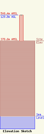
Site Elevation: 378.6 meters (1242 ft) |
| Height of Structure: 129.8 meters (426 feet) |
| Overall Height Above Ground: 129.8 meters (426 feet) |
| Overall Height Above Mean Sea Level: 508.4 meters (1668 feet) |
| Owner Info | SBA Towers IX, LLC
8051 Congress Avenue
Boca Raton, FL 33487
(561) 995-7670
ERoach@sbasite.com |
| Contact Info | SBA Towers IX, LLC
8051 Congress Avenue
Boca Raton, FL 33487
(561) 995-7670
ERoach@sbasite.com |
