|
|
Antenna Structure Registration 1025320 |
 |
Registration Info | Registration Number: 1025320 |
| File Number: A1305632 |
| FAA Study: 2018-AGL-7799-OE |
| FAA Issue Date: 06/20/2018 |
| Status: Constructed |
| Date Constructed: 06/30/2018 |
| NEPA: N |
Structure Info
| Structure Type: GTOWER |
| Structure Coordinates: 43-39-41.0 N 94-6-30.0 W (NAD 83) |
| Structure Coordinates: 43-39-41.2 N 94-06-29.1 W (Converted to NAD 27) |
| Structure Address: On Cr 6 .5 Mi N |
| Structure City: Blue Earth, MN |
| Structure County: Faribault County |
| Painting & Lighting Info |
FAA Circular #: 70/7460-1L |
FAA Chapters: 3, 4, 5, 12 |
Remarks: Continue As Is OM&L = PAINT/RED LIGHTS |
Remarks: PRIOR STUDY 1989-AGL-1305-OE |
Remarks: Removed expiration date from determination. Scenario 1./jjs/case#635066 |
Remarks: PRIOR STUDY 1989-AGL-1305-OE |
Remarks: Removed expiration date from determination. Scenario 1./jjs/case#635066 |
Remarks: Continue As Is OM&L = PAINT/RED LIGHTS |
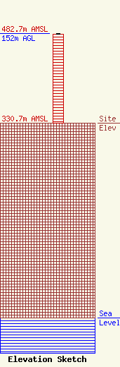
| Elevation Info |
Site Elevation: 330.7 meters (1085 ft) |
| Height of Structure: 150.9 meters (495 feet) |
| Overall Height Above Ground: 152 meters (499 feet) |
| Overall Height Above Mean Sea Level: 482.7 meters (1584 feet) |
| Owner Info | Minn-Iowa Christian Broadcasting, Inc.
860 Madison Ave
Mankato, MN 56001
(507) 526-3233
jennifer@kinshipradio.org |
| Contact Info | Minn-Iowa Christian Broadcasting, Inc./Kinship Radio
860 Madison Ave
Mankato, MN 56001
Jennifer Stokes
(507) 526-3233
jennifer@kinshipradio.org |
