|
|
Antenna Structure Registration 1025464 |
 |
Registration Info | Registration Number: 1025464 |
| File Number: A0030229 |
| FAA Study: 97-ACE-0851-OE |
| FAA Issue Date: 07/29/1997 |
| Status: Constructed |
| Date Constructed: 01/01/1968 |
| NEPA: N |
Structure Info
| Structure Type: 4TA3 |
| Structure Coordinates: 40-30-57.0 N 99-23-46.0 W (NAD 83) |
| Structure Coordinates: 40-30-57.0 N 99-23-44.6 W (Converted to NAD 27) |
| Structure Address: Twr 3 - 5 Mi N On Hwy 183 1 Mi W |
| Structure City: Holdrege, NE |
| Structure County: Phelps County |
| Painting & Lighting Info |
FAA Circular #: 70/7460-1J |
FAA Chapters: 3, 4, 5, 13 |
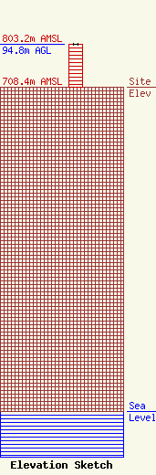
| Elevation Info |
Site Elevation: 708.4 meters (2324 ft) |
| Height of Structure: 93.9 meters (308 feet) |
| Overall Height Above Ground: 94.8 meters (311 feet) |
| Overall Height Above Mean Sea Level: 803.1 meters (2635 feet) |
| Owner Info | NEBRASKA RURAL RADIO ASSOCIATION DBA = KRVN AM
1007 PLUM CREEK PKY
880
LEXINGTON, NE 68850
(308) 324-2371
VKILLION@KRVN.COM |
