|
|
Antenna Structure Registration 1025579 |
 |
Registration Info | Registration Number: 1025579 |
| File Number: A1206597 |
| FAA Study: 74-GL-386-OE |
| FAA Issue Date: 06/13/1974 |
| Status: Constructed |
| Date Constructed: 01/01/1975 |
| NEPA: N |
Structure Info
| Structure Type: TOWER |
| Structure Coordinates: 46-50-14.0 N 95-50-17.0 W (NAD 83) |
| Structure Coordinates: 46-50-14.1 N 95-50-15.8 W (Converted to NAD 27) |
| Structure Address: 1340 Richwood Rd |
| Structure City: Detroit Lakes, MN |
| Structure County: Becker County |
| Painting & Lighting Info |
FCC Paragraph(s): 1, 3, 12, 21 |
Remarks: RED LIGHTS/PAINT |
| Elevation Info |
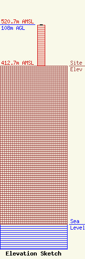
Site Elevation: 412.7 meters (1354 ft) |
| Height of Structure: 107 meters (351 feet) |
| Overall Height Above Ground: 108 meters (354 feet) |
| Overall Height Above Mean Sea Level: 520.7 meters (1708 feet) |
| Owner Info | Leighton Enterprises, Inc.
1458
St. Cloud, MN 56302
(320) 251-1450
tabfalter@leightonbroadcasting.com |
| Contact Info | Leighton Enterprises, Inc.
1458
St. Cloud, MN 56302
Tony Abfalter
(320) 251-1450
tabfalter@leightonbroadcasting.com |
