|
|
Antenna Structure Registration 1025613 |
 |
Registration Info | Registration Number: 1025613 |
| File Number: A0199822 |
| FAA Study: 00-ASO-0913-OE |
| FAA Issue Date: 11/08/2001 |
| Status: Constructed |
| Date Constructed: 10/15/2000 |
| FAA EMI: N |
| NEPA: N |
Structure Info
| Structure Type: TOWER |
| Structure Coordinates: 18-22-52.8 N 66-3-59.6 W (NAD 83) |
| Structure Coordinates: 18-22-60.0 N 66-04-01.0 W (Converted to NAD 27) |
| Structure Address: Calle Indo 1592 El Cerezal |
| Structure City: San Juan, PR |
| Structure County: San Juan Municipio |
| Painting & Lighting Info |
FAA Circular #: 70/7460-1K |
FAA Chapters: 3, 4, 5, 12 |
Remarks: PRIOR FAA # 97-ASO-1782-OE PROJECT STATUS REPORT STATES CONSTRUCTION COMPLETED ON 11/08/2001 |
| Elevation Info |
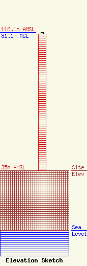
Site Elevation: 35 meters (115 ft) |
| Height of Structure: 80.2 meters (263 feet) |
| Overall Height Above Ground: 81.1 meters (266 feet) |
| Overall Height Above Mean Sea Level: 116.1 meters (381 feet) |
| Owner Info | Madifide, Inc.
363222
SAN JUAN, PR 00936-3222
(787) 758-1300
|
| Contact Info | Graham Brock, Inc.
10 Sylvan Drive, Suite 26
24466
St. Simons Island, GA 31522-7466
Marilyn Matheny
(912) 638-8028
marilyn@grahambrock.com |
