|
|
Antenna Structure Registration 1025886 |
 |
Registration Info | Registration Number: 1025886 |
| File Number: A1287716 |
| FAA Study: 2014-ACE-3217-OE |
| FAA Issue Date: 09/11/2014 |
| Status: Constructed |
| Date Constructed: 11/03/2014 |
| NEPA: N |
Structure Info
| Structure Type: GTOWER |
| Structure Coordinates: 41-59-58.4 N 103-40-32.2 W (NAD 83) |
| Structure Coordinates: 41-59-58.5 N 103-40-30.4 W (Converted to NAD 27) |
| Structure Address: 10141 Highway 71 |
| Structure City: Scottsbluff, NE |
| Structure County: Scotts Bluff County |
| Painting & Lighting Info |
FAA Circular #: 70/7460-1K |
FAA Chapters: 4, 6, 12 |
Remarks: Removed expiration date from determination. Scenario 1./jjs/case#635066 |
Remarks: PRIOR STUDY 2013-ACE-1708-OE |
Remarks: Removed expiration date from determination. Scenario 1./jjs/case#635066 |
Remarks: PRIOR STUDY 2013-ACE-1708-OE |
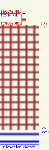
| Elevation Info |
Site Elevation: 1339.6 meters (4395 ft) |
| Height of Structure: 151.5 meters (497 feet) |
| Overall Height Above Ground: 152.1 meters (499 feet) |
| Overall Height Above Mean Sea Level: 1491.7 meters (4894 feet) |
| Owner Info | Marquee Broadcasting West, Inc.
2923 East Lincolnway
Cheyenne, WY 82001
(301) 661-9610
patricia_lane@marqueebroadcasting.com |
| Contact Info | BakerHostetler LLP
1050 Connecticut Ave NW
Washington, DC 20036
Daniel Kirkpatrick
(202) 861-1758
dkirkpatrick@bakerlaw.com |
