|
|
Antenna Structure Registration 1025952 |
 |
Registration Info | Registration Number: 1025952 |
| File Number: A1307491 |
| FAA Study: 87-AEA-1860-OE |
| FAA Issue Date: 04/20/1988 |
| Status: Constructed |
| Date Constructed: 01/01/1989 |
| NEPA: N |
Structure Info
| Structure Type: TOWER |
| Structure Coordinates: 39-51-23.0 N 76-56-56.0 W (NAD 83) |
| Structure Coordinates: 39-51-22.6 N 76-56-57.1 W (Converted to NAD 27) |
| Structure Address: 32 Laurel Woods Dr Nr |
| Structure City: Hanover, PA |
| Structure County: York County |
| Painting & Lighting Info |
FAA Circular #: 70/7460-1G |
FAA Chapters: 3, 4, 5, 9 |
| Elevation Info |
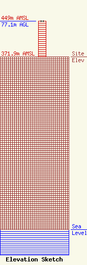
Site Elevation: 371.9 meters (1220 ft) |
| Height of Structure: 77.1 meters (253 feet) |
| Overall Height Above Ground: 77.1 meters (253 feet) |
| Overall Height Above Mean Sea Level: 449 meters (1473 feet) |
| Owner Info | GTC UNO, LLC
865
Rancho Cordova, CA 95741
(844) 482-8977
lkirth@gtctowers.com |
| Contact Info | GTC UNO, LLC
865
Rancho Cordova, CA 95741
(844) 482-8977
lkirth@gtctowers.com |
