|
|
Antenna Structure Registration 1026125 |
 |
Registration Info | Registration Number: 1026125 |
| File Number: A1122297 |
| FAA Study: 2013-AEA-6828-OE |
| FAA Issue Date: 03/14/2014 |
| Status: Constructed |
| Date Constructed: 01/01/1956 |
| FAA EMI: N |
| NEPA: N |
Structure Info
| Structure Type: GTOWER |
| Structure Coordinates: 41-11-56.0 N 75-49-5.0 W (NAD 83) |
| Structure Coordinates: 41-11-55.7 N 75-49-06.3 W (Converted to NAD 27) |
| Structure Address: Pa Route 933,3.23 Km West Of Rt 115 On Wyoming Mt. |
| Structure City: Bearcreek, PA |
| Structure County: Luzerne County |
| Painting & Lighting Info |
FAA Circular #: 70/7460-1K |
FAA Chapters: 3, 4, 5, 12 |
| Elevation Info |
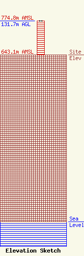
Site Elevation: 643.1 meters (2110 ft) |
| Height of Structure: 130.8 meters (429 feet) |
| Overall Height Above Ground: 131.7 meters (432 feet) |
| Overall Height Above Mean Sea Level: 774.8 meters (2542 feet) |
| Owner Info | Entercom Pennsylvania, LLC
401 E. City Avenue, Suite 809
Bala Cynwyd, PA 19004
(610) 660-5610
john.kennedy@entercom.com |
| Contact Info | Entercom Communications Corp.
1015 Half Street SE
Washington, DC 20003
Laura Berman
(484) 270-6312
laura.berman@entercom.com |
