|
|
Antenna Structure Registration 1026197 |
 |
Registration Info | Registration Number: 1026197 |
| File Number: A1063795 |
| FAA Study: 01-ACE-0374-OE |
| FAA Issue Date: 03/22/2001 |
| Status: Constructed |
| Date Constructed: 08/08/1963 |
| FAA EMI: N |
| NEPA: N |
Structure Info
| Structure Type: TOWER |
| Structure Coordinates: 40-39-27.9 N 98-52-5.0 W (NAD 83) |
| Structure Coordinates: 40-39-27.8 N 98-52-03.7 W (Converted to NAD 27) |
| Structure Address: 1738 W Road |
| Structure City: Lowell, NE |
| Structure County: Kearney County |
| Painting & Lighting Info |
FCC Paragraph(s): 1, 3, 8, 17, 21 |
Remarks: OM&L TO REMAIN PAINT RED LIGHTS |
Remarks: Removed final date from determination. Scenario 3./jjs/case#635066 |
Remarks: OM&L TO REMAIN PAINT RED LIGHTS |
Remarks: Removed final date from determination. Scenario 3./jjs/case#635066 |
| Elevation Info |
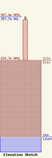
Site Elevation: 629.7 meters (2066 ft) |
| Height of Structure: 333.5 meters (1094 feet) |
| Overall Height Above Ground: 357.7 meters (1174 feet) |
| Overall Height Above Mean Sea Level: 987.4 meters (3240 feet) |
| Owner Info | KHGI Licensee, LLC
Pillsbury Winthrop Shaw Pittman LLP
Washington, DC 20036
(202) 663-8195
miles.mason@pillsburylaw.com |
| Contact Info | KHGI Licensee, LLC
Pillsbury Winthrop Shaw Pittman LLP
Washington, DC 20036
(202) 663-8195
miles.mason@pillsburylaw.com |
