|
|
Antenna Structure Registration 1026436 |
 |
Registration Info | Registration Number: 1026436 |
| File Number: A1276470 |
| FAA Study: 71-EA-563-OE |
| FAA Issue Date: 10/04/1971 |
| Status: Constructed |
| Date Constructed: 09/01/1971 |
| FAA EMI: N |
| NEPA: N |
Structure Info
|
| Structure Coordinates: 40-6-44.0 N 78-51-32.0 W (NAD 83) |
| Structure Coordinates: 40-06-43.7 N 78-51-32.9 W (Converted to NAD 27) |
| Structure Address: 3564 Ridge Rd |
| Structure City: Stoystown, PA |
| Structure County: Somerset County |
| Painting & Lighting Info |
FCC Paragraph(s): 1, 2 |
Remarks: RED LIGHTS/PAINT |
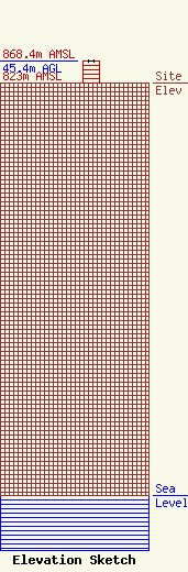
| Elevation Info |
Site Elevation: 823 meters (2700 ft) |
| Height of Structure: 44.5 meters (146 feet) |
| Overall Height Above Ground: 45.4 meters (149 feet) |
| Overall Height Above Mean Sea Level: 868.4 meters (2849 feet) |
| Owner Info | Seven Mountains Media Family, LLC
115 West Main Street
Frankfort, KY 40601
(502) 875-1130
towers@7mountainsmedia.com |
| Contact Info | Seven Mountains Media Family, LLC
135 White Bridge Rd
Middletown, NY 10940
Bud Williamson
(914) 213-1710
bud@dre.cc |
