|
|
Antenna Structure Registration 1026515 |
 |
Registration Info | Registration Number: 1026515 |
| File Number: A0428419 |
| Status: Constructed |
| Date Constructed: 07/01/1987 |
| FAA EMI: N |
| NEPA: N |
Structure Info
| Structure Type: 4TA3 |
| Structure Coordinates: 41-33-44.0 N 75-58-7.0 W (NAD 83) |
| Structure Coordinates: 41-33-43.7 N 75-58-08.3 W (Converted to NAD 27) |
| Structure Address: Twr 3 - On Us Rt 6 1.5 Mi W |
| Structure City: Tunkhannock Township, PA |
| Structure County: Wyoming County |
| Painting & Lighting Info |
FCC Paragraph(s): None |
| Elevation Info |
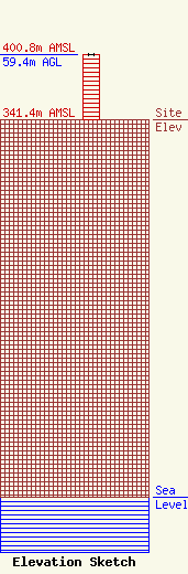
Site Elevation: 341.4 meters (1120 ft) |
| Height of Structure: 59.4 meters (195 feet) |
| Overall Height Above Ground: 59.4 meters (195 feet) |
| Overall Height Above Mean Sea Level: 400.8 meters (1315 feet) |
| Owner Info | Geos Communications
P.O. Box 701
Tunkhannock, PA 18657
(570) 836-4200
bensmith@cozyradio.com |
| Info |
