|
|
Antenna Structure Registration 1026520 |
 |
Registration Info | Registration Number: 1026520 |
| File Number: A1230321 |
| Status: Dismantled |
| Date Constructed: 01/01/1993 |
| NEPA: N |
Structure Info
|
| Structure Coordinates: 41-15-26.0 N 95-57-52.0 W (NAD 83) |
| Structure Coordinates: 41-15-26.0 N 95-57-50.9 W (Converted to NAD 27) |
| Structure Address: 35th & Farnam |
| Structure City: Omaha, NE |
| Structure County: Douglas County |
| Painting & Lighting Info |
FCC Paragraph(s): 1, 3, 4, 13, 21 |
| Elevation Info |
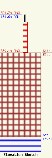
Site Elevation: 360.1 meters (1181 ft) |
| Height of Structure: 130.8 meters (429 feet) |
| Overall Height Above Ground: 161.6 meters (530 feet) |
| Overall Height Above Mean Sea Level: 521.7 meters (1712 feet) |
| Owner Info | Gray Media Group, Inc.
4370 Peachtree Road, NE
Atlanta, GA 30319
(404) 504-9828
Robert.Folliard@gray.tv |
| Contact Info | Wiley Rein LLP
1776 K Street, N.W.
Washington, DC 20006
Joan Stewart
(202) 719-7438
jstewart@wiley.law |
