|
|
Antenna Structure Registration 1026524 |
 |
Registration Info | Registration Number: 1026524 |
| File Number: A1276512 |
| FAA Study: 94-AEA-0488-OE |
| Status: Constructed |
| Date Constructed: 07/11/1996 |
| FAA EMI: N |
| NEPA: N |
Structure Info
| Structure Type: TOWER |
| Structure Coordinates: 41-4-5.0 N 78-31-6.0 W (NAD 83) |
| Structure Coordinates: 41-04-04.8 N 78-31-06.9 W (Converted to NAD 27) |
| Structure Address: 1.3 Km Se Int Us 322 & St Rt 153 |
| Structure City: Clearfield, PA |
| Structure County: Clearfield County |
| Painting & Lighting Info |
FAA Circular #: 70/7460-1H |
FAA Chapters: 3, 4, 5, 13 |
| Elevation Info |
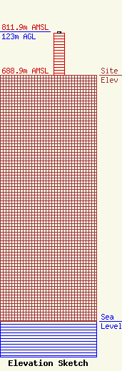
Site Elevation: 688.9 meters (2260 ft) |
| Height of Structure: 117.4 meters (385 feet) |
| Overall Height Above Ground: 123 meters (404 feet) |
| Overall Height Above Mean Sea Level: 811.9 meters (2664 feet) |
| Owner Info | Seven Mountains Media, LLC
115 West Main Street
Frankfort, KY 40601
(502) 875-1130
towers@7mountainsmedia.com |
| Contact Info | Seven Mountains Media, LLC
135 White Bridge Rd
Middletown, NY 10940
Bud Williamson
(914) 213-1710
bud@7mountainsmedia.com |
