|
|
Antenna Structure Registration 1026993 |
 |
Registration Info | Registration Number: 1026993 |
| File Number: A0512601 |
| FAA Study: 76-EA-643-OE |
| Status: Constructed |
| Date Constructed: 01/01/1952 |
| FAA EMI: N |
| NEPA: N |
Structure Info
| Structure Type: 2TOWER |
| Structure Coordinates: 41-10-57.0 N 75-52-20.0 W (NAD 83) |
| Structure Coordinates: 41-10-56.7 N 75-52-21.3 W (Converted to NAD 27) |
| Structure Address: Penobscot Knob Ext Of Sterling St |
| Structure City: Mountaintop, PA |
| Structure County: Luzerne County |
| Painting & Lighting Info |
FAA Chapters: NONE |
| Elevation Info |
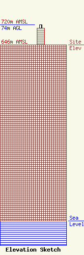
Site Elevation: 646 meters (2119 ft) |
| Height of Structure: 60 meters (197 feet) |
| Overall Height Above Ground: 74 meters (243 feet) |
| Overall Height Above Mean Sea Level: 720 meters (2362 feet) |
| Owner Info | NORTHEASTERN PENNSYLVANIA EDUCATIONAL TELEVISION ASSOCIATION
100 WVIA Way
PITTSTON, PA 18640
(570) 826-6144
joeglynn@wvia.org |
