|
|
Antenna Structure Registration 1027181 |
 |
Registration Info | Registration Number: 1027181 |
| File Number: A1341926 |
| FAA Study: 2015-ACE-3518-OE |
| FAA Issue Date: 07/19/2016 |
| Status: Constructed |
| Date Constructed: 02/18/1998 |
| NEPA: N |
Structure Info
| Structure Type: GTOWER |
| Structure Coordinates: 39-0-52.1 N 92-16-32.7 W (NAD 83) |
| Structure Coordinates: 39-00-52.0 N 92-16-32.0 W (Converted to NAD 27) |
| Structure Address: 6000 Brown Station Rd |
| Structure City: Columbia, MO |
| Structure County: Boone County |
| Painting & Lighting Info |
FAA Circular #: 70/7460-1L |
FAA Chapters: 3, 4, 5, 12 |
Remarks: PRIOR STUDY 2009-ACE-2145-OE |
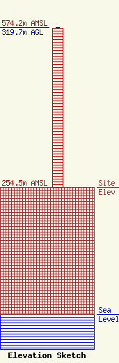
| Elevation Info |
Site Elevation: 254.5 meters (835 ft) |
| Height of Structure: 318.8 meters (1046 feet) |
| Overall Height Above Ground: 319.7 meters (1049 feet) |
| Overall Height Above Mean Sea Level: 574.2 meters (1884 feet) |
| Owner Info | VB Nimbus, LLC
22 W Atlantic Avenue
Delray Beach, FL 33444
(561) 406-4015
fcc-faa@verticalbridge.com |
| Contact Info | VB Nimbus, LLC
22 W Atlantic Avenue
Delray Beach, FL 33444
Richard Hickey
(561) 406-4015
fcc-faa@verticalbridge.com |
