|
|
Antenna Structure Registration 1027196 |
 |
Registration Info | Registration Number: 1027196 |
| File Number: A1198852 |
| FAA Study: 2021-AGL-7495-OE |
| FAA Issue Date: 08/11/2021 |
| Status: Constructed |
| Date Constructed: 07/01/1965 |
| NEPA: N |
Structure Info
| Structure Type: GTOWER |
| Structure Coordinates: 39-14-32.5 N 87-23-28.6 W (NAD 83) |
| Structure Coordinates: 39-14-32.4 N 87-23-28.5 W (Converted to NAD 27) |
| Structure Address: 0.1 Miles West Of U.s. Hwy 41 And 0.2 Miles South Of E County Rd 1100 N |
| Structure City: Farmersburg, IN |
| Structure County: Sullivan County |
| Painting & Lighting Info |
FAA Circular #: 70/7460-1M |
FAA Chapters: 3, 4, 5, 15 |
Remarks: PRIOR STUDY 2019-AGL-17883-OE |
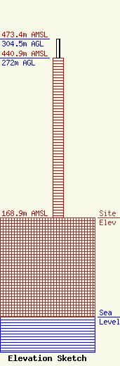
| Elevation Info |
Site Elevation: 168.9 meters (554 ft) |
| Height of Structure: 272 meters (892 feet) |
| Overall Height Above Ground: 304.5 meters (999 feet) |
| Overall Height Above Mean Sea Level: 473.4 meters (1553 feet) |
| Owner Info | Nexstar Media Inc.
545 E. John Carpenter Freeway
Irving, TX 75062
(972) 373-8800
jasroberts@nexstar.tv |
| Contact Info | Nexstar Media Inc.
545 E. John Carpenter Freeway
Irving, TX 75062
Jason Roberts
(972) 373-8800
jasroberts@nexstar.tv |
