|
|
Antenna Structure Registration 1027204 |
 |
Registration Info | Registration Number: 1027204 |
| File Number: A0473554 |
| FAA Study: 79-ACE-253-OE |
| FAA Issue Date: 08/10/1995 |
| Status: Constructed |
| Date Constructed: 01/01/1979 |
| FAA EMI: N |
| NEPA: N |
Structure Info
| Structure Type: TOWER |
| Structure Coordinates: 40-34-3.0 N 98-22-31.0 W (NAD 83) |
| Structure Coordinates: 40-34-03.0 N 98-22-29.8 W (Converted to NAD 27) |
| Structure Address: 500 East J St |
| Structure City: Hastings, NE |
| Structure County: Adams County |
| Painting & Lighting Info |
FCC Paragraph(s): 1, 3, 11, 21 |
Remarks: RED LIGHTS/PAINT |
| Elevation Info |
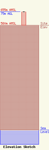
Site Elevation: 580 meters (1903 ft) |
| Height of Structure: 73.2 meters (240 feet) |
| Overall Height Above Ground: 75 meters (246 feet) |
| Overall Height Above Mean Sea Level: 655 meters (2149 feet) |
| Owner Info | KHAS Broadcasting, Inc. = KICS
726
HASTINGS, NE 68902
(000) 000-0000
|
