|
|
Antenna Structure Registration 1027231 |
 |
Registration Info | Registration Number: 1027231 |
| File Number: A1252248 |
| FAA Study: 98-AEA-1989-OE |
| FAA Issue Date: 10/07/1998 |
| Status: Constructed |
| Date Constructed: 01/01/1968 |
| FAA EMI: N |
| NEPA: N |
Structure Info
| Structure Type: 2TA1 |
| Structure Coordinates: 40-2-35.0 N 79-54-18.0 W (NAD 83) |
| Structure Coordinates: 40-02-34.7 N 79-54-18.8 W (Converted to NAD 27) |
| Structure Address: North Twr - 1.65 Mi Nw Of Brownsville Pa Btwn Pa Rt 88 & Us 40 |
| Structure City: California, PA |
| Structure County: Washington County |
| Painting & Lighting Info |
FAA Circular #: 70/7460-1J |
FAA Chapters: 4, 8, 13 |
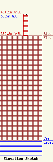
| Elevation Info |
Site Elevation: 335.3 meters (1100 ft) |
| Height of Structure: 68.9 meters (226 feet) |
| Overall Height Above Ground: 68.9 meters (226 feet) |
| Overall Height Above Mean Sea Level: 404.2 meters (1326 feet) |
| Owner Info | Forever Media, Inc.
274 Lakemont Park Blvd
Altoona, PA 16602
(412) 951-1525
fcccontact@forevermediainc.com |
| Contact Info | Forever Media, Inc.
274 Lakemont Park Blvd
Altoona, PA 16602
Lynn Deppen
(412) 951-1525
fcccontact@forevermediainc.com |
