|
|
Antenna Structure Registration 1027616 |
 |
Registration Info | Registration Number: 1027616 |
| File Number: A1285930 |
| FAA Study: 2022-AEA-9499-OE |
| FAA Issue Date: 10/25/2023 |
| Status: Constructed |
| Date Constructed: 11/21/2013 |
| NEPA: N |
Structure Info
| Structure Type: GTOWER |
| Structure Coordinates: 39-41-53.8 N 74-14-4.6 W (NAD 83) |
| Structure Coordinates: 39-41-53.4 N 74-14-06.1 W (Converted to NAD 27) |
| Structure Address: 1001 Beach Ave (203691) |
| Structure City: Manahawkin, NJ |
| Structure County: Ocean County |
| Painting & Lighting Info |
FAA Circular #: 70/7460-1K |
FAA Chapters: 4, 8, 12 |
Remarks: PRIOR STUDY 2015-AEA-2764-OE |
Remarks: OM&L to remain the same as prior study = A MED-DUAL SYSTEM |
Remarks: PRIOR STUDY 2015-AEA-2764-OE |
| Elevation Info |
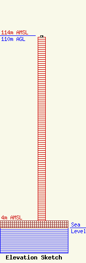
Site Elevation: 4 meters (13 ft) |
| Height of Structure: 109 meters (358 feet) |
| Overall Height Above Ground: 110 meters (361 feet) |
| Overall Height Above Mean Sea Level: 114 meters (374 feet) |
| Owner Info | American Towers LLC
10 Presidential Way
Woburn, MA 01801
(781) 926-4500
faa-fcc@americantower.com |
| Contact Info | American Towers LLC
10 Presidential Way
Woburn, MA 01801
(781) 926-4500
faa-fcc@americantower.com |
