|
|
Antenna Structure Registration 1028149 |
 |
Registration Info | Registration Number: 1028149 |
| File Number: A0033387 |
| FAA Study: 95-ASO-0678-OE |
| FAA Issue Date: 03/23/1995 |
| Status: Constructed |
| Date Constructed: 07/05/1986 |
| FAA EMI: Y |
| NEPA: N |
Structure Info
| Structure Type: TOWER |
| Structure Coordinates: 38-3-39.0 N 83-57-20.0 W (NAD 83) |
| Structure Coordinates: 38-03-38.7 N 83-57-20.3 W (Converted to NAD 27) |
| Structure Address: 805 Indian Mound Drive |
| Structure City: Mount Sterling, KY |
| Structure County: Montgomery County |
| Painting & Lighting Info |
FAA Chapters: NONE |
| Elevation Info |
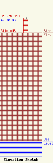
Site Elevation: 311 meters (1020 ft) |
| Height of Structure: 42.7 meters (140 feet) |
| Overall Height Above Ground: 42.7 meters (140 feet) |
| Overall Height Above Mean Sea Level: 353.7 meters (1160 feet) |
| Owner Info | MONTGOMERY COUNTY FIRE DEPARTMENT
805 INDIAN MOUND DRIVE
MOUNT STERLING, KY 40353
(606) 498-1318
|
