|
|
Antenna Structure Registration 1028296 |
 |
Registration Info | Registration Number: 1028296 |
| File Number: A1194728 |
| FAA Study: 97-ASO-3015-OE |
| FAA Issue Date: 08/01/1997 |
| Status: Constructed |
| Date Constructed: 03/14/1997 |
| FAA EMI: N |
| NEPA: N |
Structure Info
| Structure Type: TOWER |
| Structure Coordinates: 32-2-49.0 N 81-4-41.0 W (NAD 83) |
| Structure Coordinates: 32-02-48.2 N 81-04-41.6 W (Converted to NAD 27) |
| Structure Address: 1430 E. Victory Drive |
| Structure City: Savannah, GA |
| Structure County: Chatham County |
| Painting & Lighting Info |
FAA Circular #: 70/7460-1J |
FAA Chapters: 3, 4, 5, 13 |
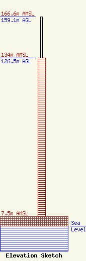
| Elevation Info |
Site Elevation: 7.5 meters (25 ft) |
| Height of Structure: 126.5 meters (415 feet) |
| Overall Height Above Ground: 159.1 meters (522 feet) |
| Overall Height Above Mean Sea Level: 166.6 meters (547 feet) |
| Owner Info | Nexstar Media Inc.
545 E. John Carpenter Freeway
Irving, TX 75062
(972) 373-8800
jasroberts@nexstar.tv |
| Contact Info | Nexstar Media Inc.
545 E. John Carpenter Freeway
Irving, TX 75062
Jason Roberts
(972) 373-8800
jasroberts@nexstar.tv |
