|
|
Antenna Structure Registration 1028735 |
 |
Registration Info | Registration Number: 1028735 |
| File Number: A1341929 |
| FAA Study: 97-ACE-0744-OE |
| Status: Constructed |
| Date Constructed: 06/01/1973 |
| FAA EMI: N |
| NEPA: N |
Structure Info
| Structure Type: TOWER |
| Structure Coordinates: 41-39-46.0 N 93-45-24.0 W (NAD 83) |
| Structure Coordinates: 41-39-46.0 N 93-45-23.2 W (Converted to NAD 27) |
| Structure Address: 5650 Nw 100th St |
| Structure City: Des Moines, IA |
| Structure County: Polk County |
| Painting & Lighting Info |
FAA Circular #: 70/7460-1J |
FAA Chapters: 3, 4, 5, 13 |
| Elevation Info |
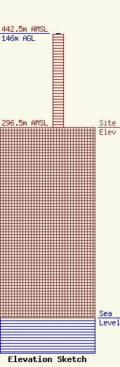
Site Elevation: 296.5 meters (973 ft) |
| Height of Structure: 145 meters (476 feet) |
| Overall Height Above Ground: 146 meters (479 feet) |
| Overall Height Above Mean Sea Level: 442.5 meters (1452 feet) |
| Owner Info | VB Nimbus, LLC
22 W Atlantic Avenue
Delray Beach, FL 33444
(561) 406-4015
fcc-faa@verticalbridge.com |
| Contact Info | VB Nimbus, LLC
22 W Atlantic Avenue
Delray Beach, FL 33444
Richard Hickey
(561) 406-4015
fcc-faa@verticalbridge.com |
