|
|
Antenna Structure Registration 1028753 |
 |
Registration Info | Registration Number: 1028753 |
| File Number: A1221697 |
| FAA Study: 1997-AGL-4742-OE |
| FAA Issue Date: 10/31/1997 |
| Status: Constructed |
| Date Constructed: 01/01/1990 |
| NEPA: N |
Structure Info
| Structure Type: BTWR |
| Structure Coordinates: 39-46-32.7 N 86-9-9.4 W (NAD 83) |
| Structure Coordinates: 39-46-32.5 N 86-09-09.4 W (Converted to NAD 27) |
| Structure Address: Riley Towers |
| Structure City: Indianapolis, IN |
| Structure County: Marion County |
| Painting & Lighting Info |
FAA Circular #: 70/7460-1J |
FAA Chapters: 4, 5, 13 |
Remarks: BANT. |
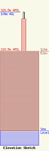
| Elevation Info |
Site Elevation: 218.5 meters (717 ft) |
| Height of Structure: 90 meters (295 feet) |
| Overall Height Above Ground: 108 meters (354 feet) |
| Overall Height Above Mean Sea Level: 326.5 meters (1071 feet) |
| Owner Info | Bible Broadcasting Network, Inc.
11530 Carmel Commons Blvd.
Charlotte, NC 28226
(704) 523-5555
jpadgett@bbnmedia.org |
| Contact Info | Smithwick & Belendiuk, P.C.
5028 Wisconsin Avenue, N.W.
Washington, DC 20016
Gary Smithwick
(202) 363-4560
gsmithwick@fccworld.com |
