|
|
Antenna Structure Registration 1028795 |
 |
Registration Info | Registration Number: 1028795 |
| File Number: A1341931 |
| FAA Study: 2005-AGL-6426-OE |
| FAA Issue Date: 10/27/2005 |
| Status: Constructed |
| Date Constructed: 04/01/1973 |
| FAA EMI: N |
| NEPA: N |
Structure Info
| Structure Type: 6TA2 |
| Structure Coordinates: 39-56-1.0 N 85-24-26.0 W (NAD 83) |
| Structure Coordinates: 39-56-00.8 N 85-24-26.1 W (Converted to NAD 27) |
| Structure Address: Twr 2 - 1134 West State Road 38 |
| Structure City: New Castle, IN |
| Structure County: Henry County |
| Painting & Lighting Info |
FAA Chapters: NONE |
Remarks: PRIOR STUDY 1998-AGL-2348-OE |
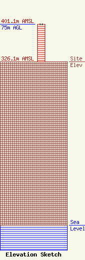
| Elevation Info |
Site Elevation: 326.1 meters (1070 ft) |
| Height of Structure: 75 meters (246 feet) |
| Overall Height Above Ground: 75 meters (246 feet) |
| Overall Height Above Mean Sea Level: 401.1 meters (1316 feet) |
| Owner Info | VB Nimbus, LLC
22 W Atlantic Avenue
Delray Beach, FL 33444
(561) 406-4015
fcc-faa@verticalbridge.com |
| Contact Info | VB Nimbus, LLC
22 W Atlantic Avenue
Delray Beach, FL 33444
Richard Hickey
(561) 406-4015
fcc-faa@verticalbridge.com |
