|
|
Antenna Structure Registration 1029445 |
 |
Registration Info | Registration Number: 1029445 |
| File Number: A0598412 |
| FAA Study: 96-ASO-5142-OE |
| FAA Issue Date: 03/28/1997 |
| Status: Constructed |
| Date Constructed: 03/28/1997 |
| FAA EMI: N |
| NEPA: N |
Structure Info
| Structure Type: TOWER |
| Structure Coordinates: 36-0-9.0 N 83-56-40.0 W (NAD 83) |
| Structure Coordinates: 36-00-08.7 N 83-56-40.3 W (Converted to NAD 27) |
| Structure Address: 331 Sharp Ridge Rd |
| Structure City: Knoxville, TN |
| Structure County: Knox County |
| Painting & Lighting Info |
FAA Chapters: NONE |
Remarks: STRUCTURE IS WITHIN 150' OF AN EXISTING 460' LIGHTED TOWER. |
| Elevation Info |
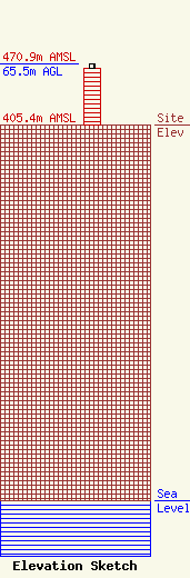
Site Elevation: 405.4 meters (1330 ft) |
| Height of Structure: 61 meters (200 feet) |
| Overall Height Above Ground: 65.5 meters (215 feet) |
| Overall Height Above Mean Sea Level: 470.9 meters (1545 feet) |
| Info |
