|
|
Antenna Structure Registration 1029633 |
 |
Registration Info | Registration Number: 1029633 |
| File Number: A1222040 |
| FAA Study: 2021-ASO-25791-OE |
| FAA Issue Date: 07/09/2021 |
| Status: Constructed |
| Date Constructed: 01/01/1985 |
| NEPA: N |
Structure Info
| Structure Type: GTOWER |
| Structure Coordinates: 27-24-31.2 N 82-14-59.3 W (NAD 83) |
| Structure Coordinates: 27-24-30.0 N 82-14-60.0 W (Converted to NAD 27) |
| Structure Address: 28350 Gopher Hill Road (#207718) |
| Structure City: Fruitville Park, FL |
| Structure County: Manatee County |
| Painting & Lighting Info |
FAA Circular #: 70/7460-1M |
FAA Chapters: 4, 9, 15 |
Remarks: PRIOR STUDY 2006-ASO-609-OE |
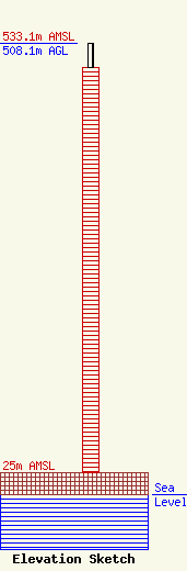
| Elevation Info |
Site Elevation: 25 meters (82 ft) |
| Height of Structure: 480.7 meters (1577 feet) |
| Overall Height Above Ground: 508.1 meters (1667 feet) |
| Overall Height Above Mean Sea Level: 533.1 meters (1749 feet) |
| Owner Info | American Towers LLC
10 Presidential Way
Woburn, MA 01801
(781) 926-4500
faa-fcc@americantower.com |
| Contact Info | American Towers LLC
10 Presidential Way
Woburn, MA 01801
(781) 926-4500
faa-fcc@americantower.com |
