|
|
Antenna Structure Registration 1029798 |
 |
Registration Info | Registration Number: 1029798 |
| File Number: A1324699 |
| FAA Study: 00-AEA-0973-OE |
| Status: Constructed |
| Date Constructed: 04/01/2002 |
| FAA EMI: N |
| NEPA: N |
Structure Info
| Structure Type: TOWER |
| Structure Coordinates: 40-57-12.3 N 76-45-3.8 W (NAD 83) |
| Structure Coordinates: 40-57-12.0 N 76-45-04.9 W (Converted to NAD 27) |
| Structure Address: West Side Of Tower Rd., Approx. 180' North Of Northumberland-montour Cty. Line |
| Structure City: Liberty Township, PA |
| Structure County: Montour County |
| Painting & Lighting Info |
FAA Circular #: 70/7460-1K |
FAA Chapters: 3, 4, 5, 12 |
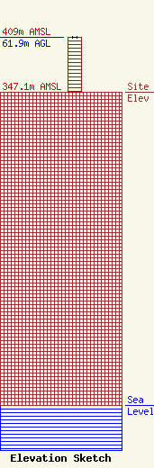
| Elevation Info |
Site Elevation: 347.1 meters (1139 ft) |
| Height of Structure: 61 meters (200 feet) |
| Overall Height Above Ground: 61.9 meters (203 feet) |
| Overall Height Above Mean Sea Level: 409 meters (1342 feet) |
| Owner Info | Michael Radio Company, LLC
1418 Bradley Avenue
Cheyenne, WY 82001
(307) 772-1322
vicmichael@RF-Towers.com |
| Contact Info | Michael Radio Company, LLC
1418 Bradley Avenue
Cheyenne, WY 82001
Victor Michael
(307) 772-1322
vicmichael@RF-Towers.com |
