|
|
Antenna Structure Registration 1029808 |
 |
Registration Info | Registration Number: 1029808 |
| File Number: A1341942 |
| FAA Study: 84-AGL-341-OE |
| FAA Issue Date: 03/21/1984 |
| Status: Constructed |
| Date Constructed: 09/01/1974 |
| FAA EMI: N |
| NEPA: N |
Structure Info
| Structure Type: POLE |
| Structure Coordinates: 40-27-4.0 N 86-2-12.0 W (NAD 83) |
| Structure Coordinates: 40-27-03.9 N 86-02-12.0 W (Converted to NAD 27) |
| Structure Address: 200 S 475 E |
| Structure City: Kokomo, IN |
| Structure County: Howard County |
| Painting & Lighting Info |
FCC Paragraph(s): 1, 3, 4, 13, 21 |
Remarks: RED LIGHTS/PAINT |
| Elevation Info |
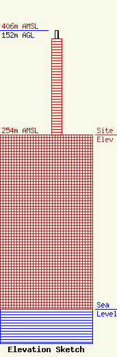
Site Elevation: 254 meters (833 ft) |
| Height of Structure: 140 meters (459 feet) |
| Overall Height Above Ground: 152 meters (499 feet) |
| Overall Height Above Mean Sea Level: 406 meters (1332 feet) |
| Owner Info | VB Nimbus, LLC
22 W Atlantic Avenue
Delray Beach, FL 33444
(561) 406-4015
fcc-faa@verticalbridge.com |
| Contact Info | VB Nimbus, LLC
22 W Atlantic Avenue
Delray Beach, FL 33444
Richard Hickey
(561) 406-4015
fcc-faa@verticalbridge.com |
