|
|
Antenna Structure Registration 1030192 |
 |
Registration Info | Registration Number: 1030192 |
| File Number: A0035775 |
| FAA Study: 97-ACE-1255-OE |
| FAA Issue Date: 09/22/1997 |
| Status: Constructed |
| Date Constructed: 06/01/1986 |
| NEPA: N |
Structure Info
| Structure Type: TOWER |
| Structure Coordinates: 41-42-37.0 N 91-35-58.0 W (NAD 83) |
| Structure Coordinates: 41-42-36.9 N 91-35-57.4 W (Converted to NAD 27) |
| Structure Address: 0.45 Mi. East Of Hwy. 965, 0.12 Mi. North Of County Road Passing Oakdale Campus |
| Structure City: Coralville, IA |
| Structure County: Johnson County |
| Painting & Lighting Info |
FAA Circular #: 70/7460-1J |
FAA Chapters: 3, 4, 5, 13 |
| Elevation Info |
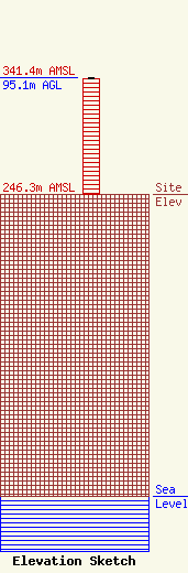
Site Elevation: 246.3 meters (808 ft) |
| Height of Structure: 94.2 meters (309 feet) |
| Overall Height Above Ground: 95.1 meters (312 feet) |
| Overall Height Above Mean Sea Level: 341.4 meters (1120 feet) |
| Owner Info | UNIVERSITY OF IOWA
3300 ENGINEERING BUILDING
IOWA CITY, IA 52242
(319) 335-5730
TEDMONDS@ICAEN.UIOWA.EDU |
