|
|
Antenna Structure Registration 1030364 |
 |
Registration Info | Registration Number: 1030364 |
| File Number: A0035984 |
| FAA Study: 90-AGL-1231-OE |
| FAA Issue Date: 07/20/1990 |
| Status: Constructed |
| Date Constructed: 07/11/1991 |
| NEPA: N |
Structure Info
| Structure Type: TOWER |
| Structure Coordinates: 43-28-9.0 N 88-49-32.0 W (NAD 83) |
| Structure Coordinates: 43-28-09.0 N 88-49-31.6 W (Converted to NAD 27) |
| Structure Address: .25 Km E Int Spring & Stoddart St |
| Structure City: Beaver Dam, WI |
| Structure County: Dodge County |
| Painting & Lighting Info |
FAA Circular #: 70/7460-1G |
FAA Chapters: 3, 4, 5, 9 |
| Elevation Info |
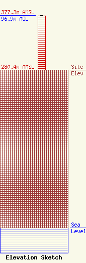
Site Elevation: 280.4 meters (920 ft) |
| Height of Structure: 96 meters (315 feet) |
| Overall Height Above Ground: 96.9 meters (318 feet) |
| Overall Height Above Mean Sea Level: 377.3 meters (1238 feet) |
| Owner Info | BEAVER DAM BROADCASTING CO INC DBA = WXRO RADIO STATION
100 STODDART ST
902
BEAVER DAM, WI 53916
(920) 885-4442
|
