|
|
Antenna Structure Registration 1030368 |
 |
Registration Info | Registration Number: 1030368 |
| File Number: A1239144 |
| FAA Study: 94-AGL-1479-OE |
| FAA Issue Date: 04/05/1994 |
| Status: Constructed |
| Date Constructed: 07/21/1989 |
| NEPA: N |
Structure Info
| Structure Type: TOWER |
| Structure Coordinates: 38-10-25.0 N 85-54-50.0 W (NAD 83) |
| Structure Coordinates: 38-10-24.7 N 85-54-50.1 W (Converted to NAD 27) |
| Structure Address: 900' Ne Of Lottick Rd & Doolittle Hill Rd |
| Structure City: Elizabeth, IN |
| Structure County: Harrison County |
| Painting & Lighting Info |
FAA Circular #: 70/7460-1H |
FAA Chapters: 4, 6, 13 |
| Elevation Info |
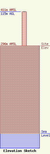
Site Elevation: 296 meters (971 ft) |
| Height of Structure: 115 meters (377 feet) |
| Overall Height Above Ground: 115 meters (377 feet) |
| Overall Height Above Mean Sea Level: 411 meters (1348 feet) |
| Owner Info | K2 Towers III, LLC
57 E Washington St
Chagrin Falls, OH 44022
(440) 528-0333
rlepene@k2towers.com |
| Contact Info | K2 Towers III, LLC
57 E Washington St
Chagrin Falls, OH 44022
Greg Thompson
(440) 528-0333
gthompson@k2towers.com |
