|
|
Antenna Structure Registration 1030448 |
 |
Registration Info | Registration Number: 1030448 |
| File Number: A1184193 |
| FAA Study: 2016-AEA-10484-OE |
| FAA Issue Date: 12/06/2016 |
| Status: Constructed |
| Date Constructed: 03/27/1998 |
| NEPA: N |
Structure Info
| Structure Type: GTOWER |
| Structure Coordinates: 41-23-29.9 N 79-48-40.9 W (NAD 83) |
| Structure Coordinates: 41-23-29.7 N 79-48-41.7 W (Converted to NAD 27) |
| Structure Address: Rd#2 Bredinsburg Rd. |
| Structure City: Franklin, PA |
| Structure County: Venango County |
| Painting & Lighting Info |
FAA Circular #: 70/7460-1L |
FAA Chapters: 4, 8, 12 |
Remarks: PRIOR STUDY 1997-AEA-2340-OE |
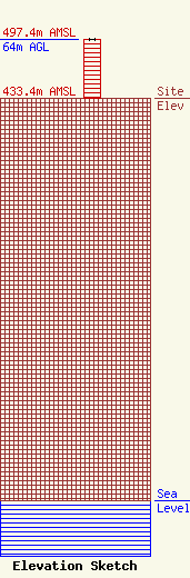
| Elevation Info |
Site Elevation: 433.4 meters (1422 ft) |
| Height of Structure: 64 meters (210 feet) |
| Overall Height Above Ground: 64 meters (210 feet) |
| Overall Height Above Mean Sea Level: 497.4 meters (1632 feet) |
| Owner Info | CTI Towers Assets II, LLC
5000 Centre Green way
Cary, NC 27513
(919) 893-2841
mbertolino@ctitowers.com |
| Contact Info | CTI Towers Assets II, LLC
5000 Centre Green way
Cary, NC 27513
Matthew Bertolino
(919) 893-2841
mbertolino@ctitowers.com |
