|
|
Antenna Structure Registration 1031001 |
 |
Registration Info | Registration Number: 1031001 |
| File Number: A1245492 |
| FAA Study: 87-AGL-233-OE |
| FAA Issue Date: 06/03/1987 |
| Status: Constructed |
| Date Constructed: 01/01/1987 |
| NEPA: N |
Structure Info
| Structure Type: TOWER |
| Structure Coordinates: 43-51-2.0 N 91-12-8.0 W (NAD 83) |
| Structure Coordinates: 43-51-02.1 N 91-12-07.5 W (Converted to NAD 27) |
| Structure Address: 1.1 Km N Of Cth B On Quarry Rd |
| Structure City: La Crosse, WI |
| Structure County: La Crosse County |
| Painting & Lighting Info |
FAA Chapters: NONE |
| Elevation Info |
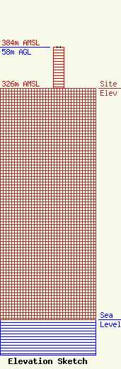
Site Elevation: 326 meters (1070 ft) |
| Height of Structure: 58 meters (190 feet) |
| Overall Height Above Ground: 58 meters (190 feet) |
| Overall Height Above Mean Sea Level: 384 meters (1260 feet) |
| Owner Info | Magnum Communications, Inc.
N6912 Highway 51 South
400
Portage, WI 53901-0400
(262) 334-2344
magcom@chorus.net |
| Contact Info | Magnum Communications, Inc.
N6912 Highway 51 South
400
Portage, WI 53901-0400
Christopher Tarr
(262) 577-9070
chris@magnum.media |
