|
|
Antenna Structure Registration 1031016 |
 |
Registration Info | Registration Number: 1031016 |
| File Number: A1381153 |
| FAA Study: 82-AGL-646-OE |
| FAA Issue Date: 07/19/1982 |
| Status: Constructed |
| Date Constructed: 08/03/1982 |
| FAA EMI: N |
| NEPA: N |
Structure Info
| Structure Type: TOWER |
| Structure Coordinates: 38-21-23.0 N 85-50-52.0 W (NAD 83) |
| Structure Coordinates: 38-21-22.8 N 85-50-52.1 W (Converted to NAD 27) |
| Structure Address: 5667 S Skyline Dr |
| Structure City: Floyds Knob, IN |
| Structure County: Floyd County |
| Painting & Lighting Info |
FAA Circular #: 70/7460-1F |
FAA Chapters: 3, 4, 5, 9 |
Remarks: RED LIGHTS/PAINT |
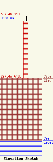
| Elevation Info |
Site Elevation: 297.4 meters (976 ft) |
| Height of Structure: 276.6 meters (907 feet) |
| Overall Height Above Ground: 300 meters (984 feet) |
| Overall Height Above Mean Sea Level: 597.4 meters (1960 feet) |
| Owner Info | Sander Operating Co. I LLC
8401 Greensboro Drive
McLean, VA 22102
(703) 873-6600
lawdept@tegna.com |
| Contact Info | TEGNA Inc.
8401 Greensboro Drive
McLean, VA 22102
Denise Branson
(703) 873-6606
dbranson@tegna.com |
