|
|
Antenna Structure Registration 1031221 |
 |
Registration Info | Registration Number: 1031221 |
| File Number: A0318672 |
| FAA Study: 83-ACE-488-OE |
| FAA Issue Date: 05/11/1983 |
| Status: Constructed |
| Date Constructed: 10/08/1983 |
| FAA EMI: N |
| NEPA: N |
Structure Info
| Structure Type: TOWER |
| Structure Coordinates: 39-7-12.0 N 100-53-9.0 W (NAD 83) |
| Structure Coordinates: 39-07-12.0 N 100-53-07.5 W (Converted to NAD 27) |
| Structure Address: 2.4 Km Sw |
| Structure City: Oakley, KS |
| Structure County: Logan County |
| Painting & Lighting Info |
FAA Circular #: 70/7460-1H |
FAA Chapters: 4, 6, 13 |
Remarks: RED LIGHTS/PAINT |
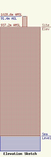
| Elevation Info |
Site Elevation: 937.2 meters (3075 ft) |
| Height of Structure: 91.4 meters (300 feet) |
| Overall Height Above Ground: 91.4 meters (300 feet) |
| Overall Height Above Mean Sea Level: 1028.6 meters (3375 feet) |
| Owner Info | Sunflower Electric Power Corporation
301 West 13th street
1020
Hays, KS 67601
(785) 628-2845
jdgeil@sunflower.net |
| Contact Info | Sunflower Electric Power Corporation
301 West 13th street
1020
Hays, KS 67601
John Geil
(785) 628-2845
jdgeil@sunflower.net |
