|
|
Antenna Structure Registration 1031470 |
 |
Registration Info | Registration Number: 1031470 |
| File Number: A1307862 |
| FAA Study: 2023-ASW-14689-OE |
| FAA Issue Date: 10/23/2023 |
| Status: Constructed |
| Date Constructed: 11/01/1996 |
| NEPA: N |
Structure Info
| Structure Type: LTOWER |
| Structure Coordinates: 32-48-56.5 N 97-7-24.3 W (NAD 83) |
| Structure Coordinates: 32-48-56.0 N 97-07-23.3 W (Converted to NAD 27) |
| Structure Address: 1450 Westpark Way (euless / Dfw Airport #9087) |
| Structure City: Euless, TX |
| Structure County: Tarrant County |
| Painting & Lighting Info |
FAA Circular #: 70/7460-1K |
FAA Chapters: 4, 8, 12 |
Remarks: OM&L to remain the same as prior study = A MED-DUAL SYSTEM |
Remarks: PRIOR STUDY 2005-ASW-1212-OE |
Remarks: OM&L to remain the same as prior study = A MED-DUAL SYSTEM |
| Elevation Info |
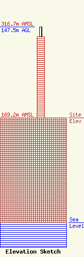
Site Elevation: 169.2 meters (555 ft) |
| Height of Structure: 131.4 meters (431 feet) |
| Overall Height Above Ground: 147.5 meters (484 feet) |
| Overall Height Above Mean Sea Level: 316.7 meters (1039 feet) |
| Owner Info | American Towers LLC
10 Presidential Way
Woburn, MA 01801
(781) 926-4500
faa-fcc@americantower.com |
| Contact Info | American Towers LLC
10 Presidential Way
Woburn, MA 01801
(781) 926-4500
faa-fcc@americantower.com |
