|
|
Antenna Structure Registration 1031724 |
 |
Registration Info | Registration Number: 1031724 |
| File Number: A0737216 |
| FAA Study: 78-SJU-9-OE |
| FAA Issue Date: 02/07/1978 |
| Status: Dismantled |
| Date Constructed: 12/20/1980 |
| FAA EMI: N |
| NEPA: N |
Structure Info
| Structure Type: TOWER |
| Structure Coordinates: 18-28-42.0 N 66-51-13.0 W (NAD 83) |
| Structure Coordinates: 18-28-49.2 N 66-51-14.4 W (Converted to NAD 27) |
| Structure Address: Urbanizacion El Maestro |
| Structure City: Camuy, PR |
| Structure County: Camuy Municipio |
| Painting & Lighting Info |
FCC Paragraph(s): 1, 3, 12, 21 |
| Remarks: RED LIGHTS/PAINT |
| Elevation Info |
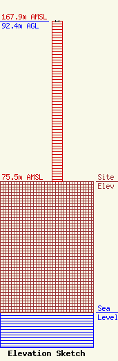
Site Elevation: 75.5 meters (248 ft) |
| Height of Structure: 92.4 meters (303 feet) |
| Overall Height Above Ground: 92.4 meters (303 feet) |
| Overall Height Above Mean Sea Level: 167.9 meters (551 feet) |
| Owner Info | HQ 103 INC
780
CAMUY, PR 00627
(787) 898-2555
|
