|
|
Antenna Structure Registration 1031841 |
 |
Registration Info | Registration Number: 1031841 |
| File Number: A1063963 |
| FAA Study: 2002-AGL-5612-OE |
| FAA Issue Date: 11/26/2002 |
| Status: Constructed |
| Date Constructed: 09/01/1960 |
| FAA EMI: N |
| NEPA: N |
Structure Info
| Structure Type: TOWER |
| Structure Coordinates: 44-16-33.2 N 85-42-48.7 W (NAD 83) |
| Structure Coordinates: 44-16-33.2 N 85-42-48.5 W (Converted to NAD 27) |
| Structure Address: 4272 South 11-1/4 Mile Road |
| Structure City: Slagle Township, MI |
| Structure County: Wexford County |
| Painting & Lighting Info |
FCC Paragraph(s): 1, 3, 8, 17, 21 |
Remarks: OM&L TO REMAIN PAINT RED LIGHTS AS PER PRIOR STUDY 2002-AGL-5101-OE |
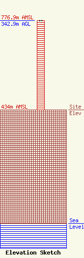
| Elevation Info |
Site Elevation: 434 meters (1424 ft) |
| Height of Structure: 342.9 meters (1125 feet) |
| Overall Height Above Ground: 342.9 meters (1125 feet) |
| Overall Height Above Mean Sea Level: 776.9 meters (2549 feet) |
| Owner Info | WPBN Licensee, LLC
Pillsbury Winthrop Shaw Pittman LLP
Washington, DC 20036
(202) 663-8195
miles.mason@pillsburylaw.com |
| Contact Info | WPBN Licensee, LLC
Pillsbury Winthrop Shaw Pittman LLP
Washington, DC 20036
(202) 663-8195
miles.mason@pillsburylaw.com |
