|
|
Antenna Structure Registration 1031888 |
 |
Registration Info | Registration Number: 1031888 |
| File Number: A1132240 |
| FAA Study: 97-ACE-1043-OE |
| FAA Issue Date: 08/25/1997 |
| Status: Constructed |
| Date Constructed: 08/01/1980 |
| FAA EMI: Y |
| NEPA: N |
Structure Info
| Structure Type: TOWER |
| Structure Coordinates: 39-0-53.0 N 96-52-13.0 W (NAD 83) |
| Structure Coordinates: 39-00-53.0 N 96-52-12.0 W (Converted to NAD 27) |
| Structure Address: 805 S. Springvalley Road |
| Structure City: Junction City, KS |
| Structure County: Geary County |
| Painting & Lighting Info |
FAA Circular #: 70/7460-1J |
FAA Chapters: 3, 4, 5, 13 |
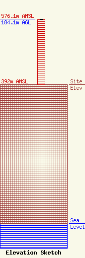
| Elevation Info |
Site Elevation: 392 meters (1286 ft) |
| Height of Structure: 183.3 meters (601 feet) |
| Overall Height Above Ground: 184.1 meters (604 feet) |
| Overall Height Above Mean Sea Level: 576.1 meters (1890 feet) |
| Owner Info | Eagle Communications Inc
2703 Hall Street
Hays, KS 67601
(816) 558-0010
kevin.wagner@eagleradio.net |
| Contact Info | Eagle Communications, Inc.
2703 Hall Street
Hays, KS 67601
Kevin Wagner
(785) 625-4000
kevin.wagner@eagleradio.net |
