|
|
Antenna Structure Registration 1031955 |
 |
Registration Info | Registration Number: 1031955 |
| File Number: A1206217 |
| FAA Study: 2014-ASW-8621-OE |
| FAA Issue Date: 12/11/2014 |
| Status: Constructed |
| Date Constructed: 12/28/2014 |
| NEPA: N |
Structure Info
| Structure Type: GTOWER |
| Structure Coordinates: 32-40-13.0 N 93-56-0.0 W (NAD 83) |
| Structure Coordinates: 32-40-12.5 N 93-55-59.3 W (Converted to NAD 27) |
| Structure Address: 7165 St. John's Baptist Church Rd. |
| Structure City: Mooringsport, LA |
| Structure County: Caddo Parish |
| Painting & Lighting Info |
FAA Circular #: 70/7460-1J |
FAA Chapters: 3, 4, 5, 13 |
Remarks: PRIOR FAA STUDY 1997-ASW-1528-OE. FAA CHAPTERS 3,4,5,13; 70/7460-1J with bird deviation special condition. |
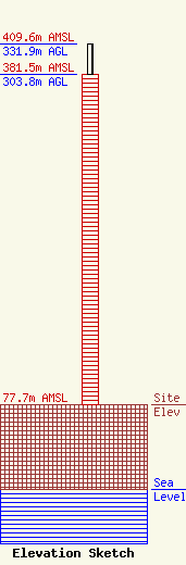
| Elevation Info |
Site Elevation: 77.7 meters (255 ft) |
| Height of Structure: 303.8 meters (997 feet) |
| Overall Height Above Ground: 331.9 meters (1089 feet) |
| Overall Height Above Mean Sea Level: 409.6 meters (1344 feet) |
| Owner Info | Townsquare Media Shreveport, LLC
1 Manhattanville Road
Purchase, NY 10577
(203) 861-0900
fcccontact@townsquaremedia.com |
| Contact Info | Townsquare Media Shreveport, LLC
1 Manhattanville Road
Purchase, NY 10577
(203) 861-0900
fcccontact@townsquaremedia.com |
