|
|
Antenna Structure Registration 1032005 |
 |
Registration Info | Registration Number: 1032005 |
| File Number: A1247337 |
| FAA Study: 2022-ACE-2964-OE |
| FAA Issue Date: 06/17/2022 |
| Status: Constructed |
| Date Constructed: 06/30/2022 |
| NEPA: N |
Structure Info
| Structure Type: GTOWER |
| Structure Coordinates: 37-13-15.0 N 94-42-26.0 W (NAD 83) |
| Structure Coordinates: 37-13-14.8 N 94-42-25.2 W (Converted to NAD 27) |
| Structure Address: Int Hwy 69 & Lawton Rd 4 Mi W Of Lawton Ks |
| Structure City: Pittsburg, KS |
| Structure County: Cherokee County |
| Painting & Lighting Info |
FAA Circular #: 70/7460-1M |
FAA Chapters: 4, 9, 15 |
Remarks: PRIOR STUDY 2017-ACE-6793-OE |
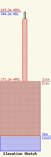
| Elevation Info |
Site Elevation: 271.2 meters (890 ft) |
| Height of Structure: 310.3 meters (1018 feet) |
| Overall Height Above Ground: 344.1 meters (1129 feet) |
| Overall Height Above Mean Sea Level: 615.3 meters (2019 feet) |
| Owner Info | QueenB Television of Kansas/Missouri, LLC
7025 Raymond Road
Madison, WI 53719-5371
(608) 271-4321
glenn@embtv.com |
| Contact Info | Rini O'Neil, PC
Suite 600
Washington, DC 20036
Jonathan Allen
(202) 955-3933
jallen@telecommediatechlaw.com |
