|
|
Antenna Structure Registration 1032031 |
 |
Registration Info | Registration Number: 1032031 |
| File Number: A1132239 |
| FAA Study: 85-ACE-135-OE |
| FAA Issue Date: 05/17/1985 |
| Status: Constructed |
| Date Constructed: 01/07/1986 |
| NEPA: N |
Structure Info
| Structure Type: TOWER |
| Structure Coordinates: 39-9-21.0 N 96-36-45.0 W (NAD 83) |
| Structure Coordinates: 39-09-21.0 N 96-36-44.0 W (Converted to NAD 27) |
| Structure Address: Stagg Hill |
| Structure City: Manhattan, KS |
| Structure County: Riley County |
| Painting & Lighting Info |
FAA Circular #: 70/7460-1F |
FAA Chapters: 3, 4, 5, 9 |
Remarks: RED LIGHTS/PAINT |
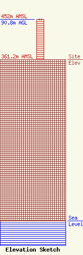
| Elevation Info |
Site Elevation: 361.2 meters (1185 ft) |
| Height of Structure: 89.9 meters (295 feet) |
| Overall Height Above Ground: 90.8 meters (298 feet) |
| Overall Height Above Mean Sea Level: 452 meters (1483 feet) |
| Owner Info | Eagle Communications Inc
2703 Hall Street
Hays, KS 67601
(816) 558-0010
kevin.wagner@eagleradio.net |
| Contact Info | Eagle Communications, Inc.
2703 Hall Street
Hays, KS 67601
Kevin Wagner
(785) 625-4000
kevin.wagner@eagleradio.net |
