|
|
Antenna Structure Registration 1032043 |
 |
Registration Info | Registration Number: 1032043 |
| File Number: A1099760 |
| FAA Study: 94-ANM-0747-OE |
| FAA Issue Date: 11/17/1994 |
| Status: Constructed |
| Date Constructed: 05/21/1975 |
| FAA EMI: N |
| NEPA: N |
Structure Info
| Structure Type: TOWER |
| Structure Coordinates: 43-12-23.0 N 123-21-51.0 W (NAD 83) |
| Structure Coordinates: 43-12-23.6 N 123-21-46.7 W (Converted to NAD 27) |
| Structure Address: Mt. Nebo |
| Structure City: Roseburg, OR |
| Structure County: Douglas County |
| Painting & Lighting Info |
FCC Paragraph(s): 1, 2 |
Remarks: RED LIGHTS/PAINT |
| Elevation Info |
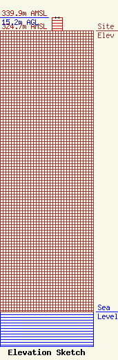
Site Elevation: 324.7 meters (1065 ft) |
| Height of Structure: 15.2 meters (50 feet) |
| Overall Height Above Ground: 15.2 meters (50 feet) |
| Overall Height Above Mean Sea Level: 339.9 meters (1115 feet) |
| Owner Info | Brooke Communications, Inc.
345 NE Winchester St.
Roseburg, OR 97470
(541) 672-6641
pat@bciradio.com |
| Contact Info | Garvey Schubert Barer
1000 Potomac Street, N.W.
Washington, DC 20007
(202) 965-7880
mvirtue@gsblaw.com |
